 A recent article in The Atlantic provided both an in-depth look into Google’s approach to building its maps as well as the subject of my first blog entry — only a full year after the Social Media gathering at INFORMS 2011 where @miketrick, @mrbojensen, and @parubin motivated and encouraged me to finally start.
I *really* like Google Maps. I use it on my phone almost daily. I love the fact that it incorporates traffic into the routing. I know it’s getting better all the time, but I can’t say that my directions have always been accurate. I’ve been “routed” through dead-ends and sent to wrong neighborhoods on more than a few occasions.
It’s very interesting how Google has developed and improved Google Maps over the years. Starting with the TIGER data from the US Census Bureau and other data sources, then improving it via human intervention they got a great start. Then, they sent out cars equipped with cameras, GPS, and other recording equipment to get the “driver’s eye-view” of each route.
Let’s step back a tiny bit to recall with wonderment the idea that a single company decided to drive cars with custom cameras over every road they could access. Google is up to five million miles driven now. Each drive generates two kinds of really useful data for mapping. One is the actual tracks the cars have taken; these are proof-positive that certain routes can be taken. The other are all the photos.
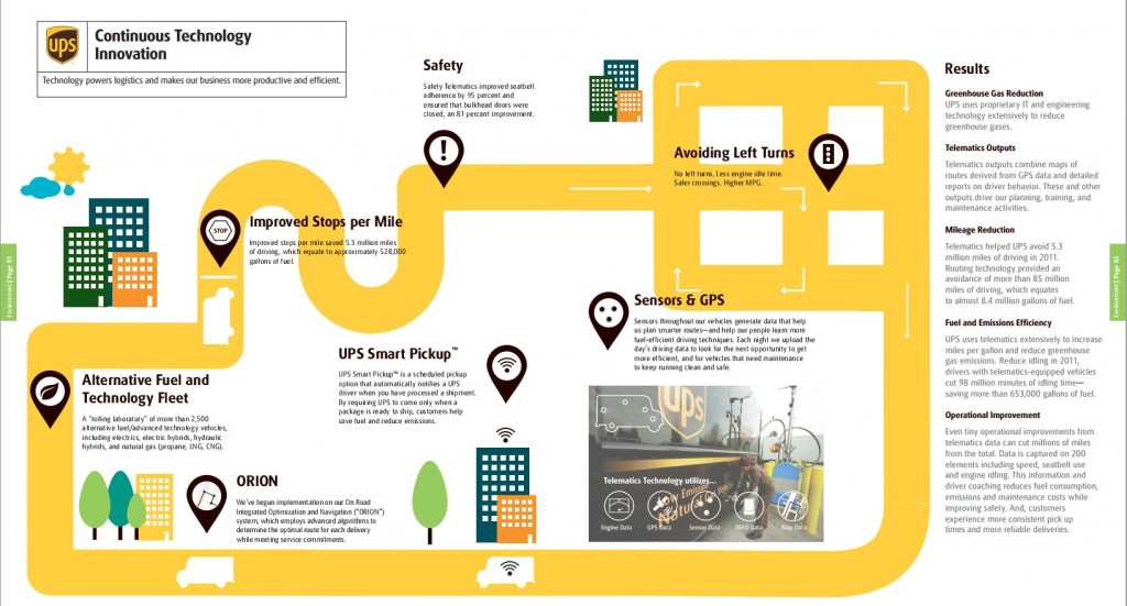
Google is up to five million miles driven now. That’s an amazing number of miles for a software/technology company. But it’s only a fraction of what a transportation company like UPS does in any given year. To get a little perspective of the miles driven by a transportation company, UPS has recorded 246 million miles just in Alternative Fuel and Advanced Technology Vehicles since 2000.
Full disclosure: I spent almost eight years in the Data Mining & Advanced Analytics group at UPS. It was a great role for me as an Operations Research practitioner, and working for the world’s largest package delivery company allowed me to see the massive scale of such an operation — and help improve some of the processes. With that said, I was taken aback a bit at this passage in the article:
I came away convinced that the geographic data Google has assembled is not likely to be matched by any other company. The secret to this success isn’t, as you might expect, Google’s facility with data, but rather its willingness to commit humans to combining and cleaning data about the physical world.
According to the 2011 UPS Corporate Sustainability Report, UPS operates 101,121 ground vehicles. I couldn’t find a total for miles driven, but if each vehicle travels 100 miles per workday (a conservative estimate), that comes out to more than 2.6 billion miles per year. In fact, the number is so large that just improving stops per mile saved 5.3 million miles of traveling in 2011 as noted in the graphic below:
Clearly, having accurate maps is vitally important to UPS. Each of the 100,000+ drivers is equipped with a Delivery Information Acquisition Device (DIAD), a hand-held device that has many functions and capabilities, including recording the GPS location of every delivery.
At 15.8 million deliveries per day, imagine a map that holds each of those points. Over a short period of time, a very accurate distribution of the location of just about every home and business address in the US can be generated. With only a few deliveries, the center-of-mass of that address could effectively cancel out much of the GPS-generated error in location. With the UPS Telematics Project sampling the location of each of the 100,000+ vehicles throughout the day, a similar distribution of road locations, parking lot lanes, and even typical traffic patterns can emerge. As a side note for a possible future blog post, Dr. Helen Bush, formerly part of the UPS Data Mining & Advanced Analytics group, developed some state-of-the-art algorithms that accurately predicted future vehicle malfunctions/breakdowns from the sensor data on each of those cars — there are lots of interesting ways to use location/sensor data that add value to the bottom line.
So, while this is a great project for a company like Google, accurate mapping is a strategic core initiative for a company like UPS. Google’s human intervention can correct many of the mistakes in the data, but it’s not a match for the massive amount of real-time data collected by UPS. I would imagine that no company in the world will ever have more accurate maps than one that has over 100,000 GPS-enabled vehicles traveling those roads every day.
A completely unscientific 9997 views and counting…thanks for visiting my blog!

